Weather Warning
IDW60281
Australian Government Bureau of Meteorology
Western Australia
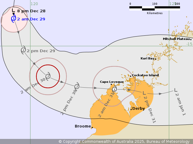
Tropical Cyclone Forecast Track Map – WA
Issued at 2:56 AM WST on Monday 29 Dec 2025.
Tropical Cyclone Hayley is forecast to approach the west Kimberley coast during Tuesday.
Warning Zones
None.
Watch Zones
Broome to Cockatoo Island, including Derby.
Cancellation Zones
None.
Details of Tropical Cyclone Hayley at 2:00 am AWST
Intensity: category 1, sustained winds near the centre of 85 kilometres per hour with wind gusts to 120 kilometres per hour
Location: within 45 kilometres of 14.0 degrees South, 119.4 degrees East, 535 kilometres northwest of Broome, 590 kilometres northwest of Derby
Movement: south at 8 kilometres per hour
Tropical Cyclone Hayley 08U has developed well northwest of the Kimberley coast and is strengthening as it moves south. Hayley is forecast to track southwards and then turn to the southeast late Monday, towards the western Kimberley coast. It is forecast to turn more easterly during Tuesday and on Wednesday. From later Tuesday, atmospheric conditions become unfavourable for the system to develop further, and 08U may begin to weaken as it approaches and crosses the western Kimberley coast Tuesday night or Wednesday.
Hazards
GALES with DAMAGING WIND GUSTS to 100 km/h may develop over the Dampier Peninsula Tuesday afternoon, extending east to Cockatoo Island overnight Tuesday. Gales may develop over the watch area as early as Tuesday morning if the system moves faster than forecast.
DESTRUCTIVE WIND GUSTS to 140 km/h are possible about the coastal fringe north of Broome to Cape Leveque late Tuesday, if the system moves faster than forecast.
Widespread moderate to locally HEAVY RAINFALL which may lead to FLASH FLOODING is possible for the watch area from Tuesday.
Tides will be higher than normal as 08U approaches the west Kimberley Coast.
Recommended Action:
DFES Advises: Ensure you know what to do in a cyclone. For the latest DFES community alerts and warnings visit www.emergency.wa.gov.au or download the Emergency WA app.
The next Forecast Track Map will be issued by 9:00 am AWST Monday